Project: NPL Site, Bulk Chemical Transporter, NJ
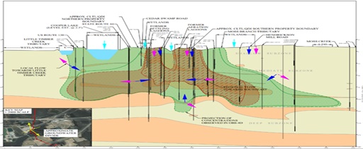
Download our Hydrogeologic Data Visualization Conceptual Site Model here: Hydrogeologic Data Visualization CSM
Objectives:
- Synthesize decades of multimedia environmental and remediation data
- Develop a comprehensive understanding of COC mass and flux
- Generate quantitative and graphic conceptual models
- Render opinion of hydrogeologic and contaminant conditions
- Provide recommendations for addressing data gaps and optimization of remedial program
- Prepare deliverable addressing broad EPA requests
Applied Science/Technologies:
- Data Visualization
- ArcGIS
- AutoCAD
- Parametric & non parametric trend analysis
- Geochemical evaluation of changes in DNAPL composition including fractional distillation analysis
- Quantitative groundwater fate and transport and capture zone assessment
Brownfield Science & Technology, Inc. (BSTI) generated a comprehensive Conceptual Site Model (CSM) document for the NPL site to satisfy USEPA requirements. The CSM included extensive data evaluation of soil, groundwater and remedial performance data with respect to COC concentration trends, COC mass, and groundwater mass flux.
Groundwater elevation and VOC concentration contours were presented in numerous maps, cross-sections, and in time series plots. Trends in parent and daughter chlorinated VOC concentrations in groundwater were evaluated from the 1980s through the present, encompassing both pre-remedial and post-remedial periods.
Graphical assessment of time series plots was performed along with linear and exponential regression analysis. Non-parametric trend (Mann-Kendall test) methods were also used to evaluate the temporal trend in parent and daughter chlorinated VOC concentrations. This evaluation was utilized to estimate the time required to achieve closure goals under current operating conditions.
BSTI developed recommendations for closure of operable units, optimization of the groundwater pump and treat system, and refinement of the long-term groundwater monitoring network. Refinements to the groundwater monitoring program focused on source area and plume axis characterization, rather than demonstration of plume capture to facilitate the eventual transition to monitored natural attenuation as a remedy.
An additional recommendation was to reduce the frequency of sampling of secondary COCs including SVOCs and metals from annual to annually to every five years. BSTI’s work was positively received by the USEPA and ultimately led to beneficial outcomes for our client.